Crescent Lake
Metaline Falls, Washington · 2,582 ft
Aerial view · USGS / USDA NAIP · Public domain · source
Wildfire 32 mi E: Upper Smith, 4,848 acres, 41% contained
At a glance
3 of 8 facts known · Forest Service data, checked Oct 3, 2026
- Elevation
- 2,582 ft (787 m)2,582 ft787 m
- Land
- Colville National Forest
U.S. Forest Service
Amenities
From OpenStreetMap, USFS INFRA Recreation Sites · Correct
- Tent sites
From OpenStreetMap, USFS INFRA Recreation Sites
You could be the first camper hereYou could be the first camper on this page
Stayed here? Share what the next camper should know.
Free account · no email needed to browse
About
Crescent lake is a beautiful 21.6 acre, emerald green lake. This lake is located nine miles north of Metaline Falls, WA, and just one mile south of the Canadian border. Open season runs from the last Saturday in April through October 31. This lake receives annual plantings of rainbow trout. A small rustic, three site campground lies just above the lake. Amenities include: tables, fire rings, a concrete vault toilet, and an animal proof garbage can. No potable water is available. It is best suited for small RV's or tent camping.
History: Bill Buffington was interviewed by John Ogmundson about his younger days and trails in the early 1900's up near Metaline Falls, Washington. Bill talked about there being a lot of gold washers coming up the river. They would come up the old mining trail from Waneta where the last bridge is on the river before it goes into the Columbia. That trail came all the way up the Columbia River and around the west bank of the Pend Oreille all the way down to Metaline Falls at the top of the hill, also known as old Blue Ribbon Trail. Cooper's trail was a good wide trail he said. A trail out to Coooper's cook shack used to cross the river at Z Canyon, where one of the forks led up to an old cabin above Crescent Lake.
From OpenStreetMap and USFS INFRA Recreation Sites · · Edit
Cell service
Report signalFCC map: no coverage reported
- VerizonNo coverage on FCC map
- AT&TNo coverage on FCC map
- T-MobileNo coverage on FCC map
Cell service at Crescent Lake: FCC map Dec 2025
Weather
National Weather Service
- TueWidespread Frost then Mostly Sunny, 3% chance of rain54°35°
- WedAreas Of Frost then Mostly Sunny58°35°
- ThuMostly Sunny63°37°
- FriSunny67°39°
- SatMostly Sunny, 3% chance of rain61°36°
Nearby camping
SeeSee all on the map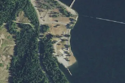
Forebay Recreation Area
Campground · 1.7 mi · Metaline Falls
Meta
Campground · 7.6 mi
Shambhala Music Festival
Campground · 7.9 mi
3 more within 25 mi
Dispersed camping nearby
Free dispersed camping within 19 mi, on public land.
- 9.1 mi
Moon Flats
Metaline Falls, WA · On U.S. Forest Service land · Colville National Forest
- 10 mi
Sullivan Creek 1
Metaline Falls, WA · On U.S. Forest Service land · Colville National Forest
- 11 mi
Sullivan Creek Campground 4
Metaline Falls, WA · On U.S. Forest Service land · Colville National Forest
- 11 mi
Sullivan Creek Campground 3
Metaline Falls, WA · On U.S. Forest Service land · Colville National Forest
- 11 mi
Sullivan Creek Campground 4
Metaline Falls, WA · On U.S. Forest Service land · Colville National Forest
- 11 mi
Sullivan Creek Campground 9
Metaline Falls, WA · On U.S. Forest Service land · Colville National Forest
Location and contact
Data from OpenStreetMap, USFS INFRA Recreation Sites
Something wrong here? Suggest an edit
Run this campground? Claim the listing