Pine Ridge Recreation Area
New Bloomfield, Missouri · 794 ft
Aerial view · USGS / USDA NAIP · Public domain · source
At a glance
3 of 8 facts known · Forest Service data, checked Oct 3, 2026
- Elevation
- 794 ft (242 m)794 ft242 m
- Land
- Mark Twain National Forest
U.S. Forest Service
Amenities
You could be the first camper hereYou could be the first camper on this page
Stayed here? Share what the next camper should know.
Free account · no email needed to browse
About
This campground and day use area is located in a pine forest. The short-leaf pine surrounding the area was planted by the CCC in the 1930.This is popular spot for visitors using the 36-mileCedar Creek Trail to stop for the night. A large field in the day use area is perfect for tossing around a frisbee.
Fees: Overnight Use:
From OpenStreetMap, Overture Maps Foundation — Places, USDA Forest Service — Recreation Opportunities, and USFS INFRA Recreation Sites · · Edit
Cell service
Report signal- Verizon5G · 4G LTE
- AT&T4G LTE
- T-MobileNo coverage on FCC map
Cell service at Pine Ridge Recreation Area: FCC map Dec 2025
Weather
National Weather Service
- WedShowers And Thunderstorms, 92% chance of rain76°66°
- ThuShowers And Thunderstorms, 96% chance of rain79°47°
- FriMostly Sunny, 8% chance of rain59°36°
- SatSunny63°40°
- SunSunny71°47°
Nearby camping
SeeSee all on the map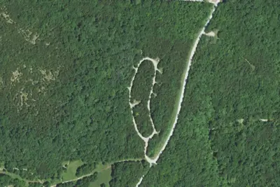
Dry Fork Recreation Area
Public Land · 2.0 mi · New Bloomfield
Hart Creek Conservation Area
Campground · 11 mi · Hartsburg
Rock Bridge Memorial State Park Special Use Area
State Park · 12 mi · Pierpont
3 more within 25 mi
Location and contact
Data from OpenStreetMap, Overture Maps Foundation — Places, USDA Forest Service — Recreation Opportunities, USFS INFRA Recreation Sites
Something wrong here? Suggest an edit
Run this campground? Claim the listing