Marion Creek Campground
Coldfoot, Alaska · 1,115 ft · In Dalton Highway
Photos: Thomas Hartmann / BLM Volunteer
At a glance
5 of 8 facts known · recreation.gov, checked Oct 3, 2026
- Elevation
- 1,115 ft (340 m)1,115 ft340 m
Loops2
Pick a loop to see its sites.
From recreation.gov's site list, Oct 10, 2026: 1 staff entry left out. Loop names are trimmed and merged.
Amenities
From BLM National Recreation Sites & Facilities, OpenStreetMap, Recreation.gov, Recreation.gov — campground rate cards · Correct
- Caravan / RV sites
- Drinking water
- Picnic tables
- Pull-through sites
- Tent sites
- Toilets
From BLM National Recreation Sites & Facilities, OpenStreetMap, Recreation.gov, Recreation.gov — campground rate cards
You could be the first camper hereYou could be the first camper on this page
Stayed here? Share what the next camper should know.
Free account · no email needed to browse
About
Overview
Marion Creek Campground is nestled on the south side of the Brooks Range in the Middle Fork Koyukuk River valley. It offers vistas of the Brooks Range and has access to the nearby undeveloped trail up to Marion Creek falls. The campground is a perfect basecamp for exploring Alaska’s Brooks Range. There are 27 sites, three of which are accessible. The site is located five miles north of Coldfoot.
This location is available on a first-come, first-serve basis only. Visitors are required to physically arrive at the campground to claim and purchase a site. Once on-site, you can pay for your campsites(s) by scanning a QR code using the Recreation.gov mobile app. Download the free Recreation.gov mobile app on Android or iOS prior to your arrival as this is a remote area that has limited or no cellular service. More reliable cellular service can be found 5 miles south in Coldfoot.
From BLM National Recreation Sites & Facilities, OpenStreetMap, Recreation.gov, and Recreation.gov — campground rate cards · · Edit
Cell service
Report signalFCC map: no coverage reported
- VerizonNo coverage on FCC map
- AT&TNo coverage on FCC map
- T-MobileNo coverage on FCC map
Cell service at Marion Creek Campground: FCC map Dec 2025
Weather
National Weather Service
- TueSlight Chance Rain And Snow, 22% chance of rain39°25°
- WedChance Light Snow, 25% chance of rain34°16°
- ThuMostly Sunny, 1% chance of rain30°18°
- FriChance Light Snow, 29% chance of rain32°17°
- SatSlight Chance Light Snow then Cloudy, 21% chance of rain28°10°
Nearby camping
SeeSee all on the map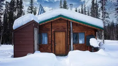
Location and contact
Data from BLM National Recreation Sites & Facilities, OpenStreetMap, Recreation Information Database (RIDB) / Recreation.gov, Recreation.gov — campground rate cards
Something wrong here? Suggest an edit
Run this campground? Claim the listing