Devil's Elbow Campground
Helena Valley Northeast, Montana · 3,724 ft · In Hauser Lake
Photos: BLM
At a glance
6 of 8 facts known · recreation.gov, checked Oct 3, 2026
- Elevation
- 3,724 ft (1,135 m)3,724 ft1,135 m
Loops3
Pick a loop to see its sites.
- Loop A15 sites15 standard · up to 60 ft
- Loop B22 sites22 standard · up to 60 ft
- TENT5 sites5 tent only · tents only
Other areas
From recreation.gov's site list, Oct 10, 2026: 6 staff entries left out. Loop names are trimmed and merged.
Amenities
From BLM National Recreation Sites & Facilities, OpenStreetMap, Overture Maps Foundation — Places, Recreation.gov, Recreation.gov — campground rate cards · Correct
- ADA accessible
- Campfires allowed
- Drinking water
From BLM National Recreation Sites & Facilities, OpenStreetMap, Overture Maps Foundation — Places, Recreation.gov, Recreation.gov — campground rate cards
You could be the first camper hereYou could be the first camper on this page
Stayed here? Share what the next camper should know.
Free account · no email needed to browse
About
Overview
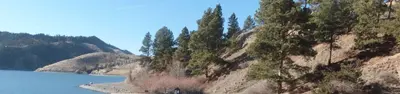
Devil's Elbow Recreation Area is situated on the picturesque "Devil's Elbow" of Hauser Lake. Just a short drive from Helena, the area offers stunning views of the Big Belt and Elkhorn mountains. The area is overflowing with outdoor adventure opportunities. Whether you're into fishing, hunting, wildlife viewing, hiking, mountain biking, boating or all of the above; all of these things are immediately accessed from (the greater) Hauser Lake Recreation Area. There is surely an activity for everyone! While just a short drive from Helena, the state capital; the feeling of seclusion and abundant nature is sure to impress.Recreation
Devil's Elbow offers excellent recreational access. Devil's Elbow has a small beach area, picnic areas, as well as a ramada/pavilion with power and lights, available by advanced reservation. There are vault toilets located in convenient locations throughout the area. There is a network of non-motorized dirt, gravel and paved trails throughout Devil's Elbow, Two Camps Vista and Clark's Bay that allow you to walk or bike around the area without contending with vehicles. There are multiple trails within the larger Hauser Lake Recreation area, as well as multiple fishing access sites, hunting access, wildlife viewing and of course, boating. There are several world class mountain biking trails in the area as well. The recreation opportunities in the area are truly boundless.
From BLM National Recreation Sites & Facilities, OpenStreetMap, Overture Maps Foundation — Places, Recreation.gov, and Recreation.gov — campground rate cards · · Edit
Cell service
Report signal- Verizon4G LTE
- AT&T4G LTE
- T-Mobile5G · 4G LTE
Cell service at Devil's Elbow Campground: FCC map Dec 2025
Weather
National Weather Service
- TuePatchy Fog43°24°
- WedMostly Sunny48°32°
- ThuSunny61°33°
- FriSunny68°38°
- SatMostly Sunny70°39°
Nearby camping
SeeSee all on the map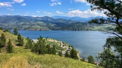
White Sandy Campground
Public Land · 4.6 mi · Helena Valley Northeast
Riverside Campground
Public Land · 4.7 mi · York
Black Sandy State Park Campground
State Park · 4.8 mi · Helena Valley Northeast
3 more within 25 mi
Dispersed camping nearby
Free dispersed camping within 19 mi, on public land.
Location and contact
Data from BLM National Recreation Sites & Facilities, OpenStreetMap, Overture Maps Foundation — Places, Recreation Information Database (RIDB) / Recreation.gov, Recreation.gov — campground rate cards
Something wrong here? Suggest an edit
Run this campground? Claim the listing