Charlton Recreation Area
Crystal Springs, Arkansas · 646 ft · In Ouachita National Forest
Photos: Bill Jackson - US Forest Service
Photos taken nearby
From Wikimedia Commons, taken close to this campground — not necessarily pictures of it.
At a glance
6 of 8 facts known · recreation.gov, checked Sep 24, 2026
- Elevation
- 646 ft (197 m)646 ft197 m
Loops3
Pick a loop to see its sites.
From recreation.gov's site list, Oct 10, 2026. Loop names are trimmed and merged.
Amenities
From Recreation.gov, Recreation.gov — campground rate cards, USDA Forest Service — Recreation Opportunities, USFS INFRA Recreation Sites · Correct
- Campfires allowed
From Recreation.gov, Recreation.gov — campground rate cards, USDA Forest Service — Recreation Opportunities, USFS INFRA Recreation Sites
You could be the first camper hereYou could be the first camper on this page
Stayed here? Share what the next camper should know.
Free account · no email needed to browse
About
Overview
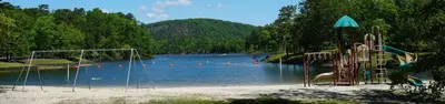
Charlton Campground is located 17-miles west of Hot Springs National Park along Highway 270-West. This historic campground constructed by the Civilian Conservation Corps (CCC) in the 1930's has been upgraded with modern amenities. Known as one of the coldest swimming sites in the State of Arkansas, the cool water temperatures can be enjoyed through-out the summer months.
Recreation
Charlton Recreation Area offers a developed day use with swimming and picnicking facilities. A large pavilion is located in the day use area. The swimming area is known by area residents as being some of the coldest water through-out the summer months. Walnut Creek, a spring-fed stream provides refreshing water in the swim site. Hiking trails are located in and around the campground. An amphitheater is located in the day use area for group gatherings. Campsites are available from a basic campsite to more developed with additional amenities, to include 30-50 amp electrical service, water connections and some sites offering sewer connections. A dump station is located at the campground. Walnut Creek runs through the campground and access is available for wading and fishing in the creek.
From Recreation.gov, Recreation.gov — campground rate cards, USDA Forest Service — Recreation Opportunities, and USFS INFRA Recreation Sites · · Edit
Cell service
Report signal- Verizon4G LTE
- AT&T4G LTE
- T-MobileNo coverage on FCC map
Cell service at Charlton Recreation Area: FCC map Dec 2025
Weather
National Weather Service
- WedSlight Chance Showers And Thunderstorms then Chance Showers And Thunderstorms, 54% chance of rain89°66°
- ThuSunny, 6% chance of rain89°59°
- FriMostly Sunny, 4% chance of rain71°44°
- SatSunny68°42°
- SunSunny73°48°
Nearby camping
SeeSee all on the map
Loop A
Dispersed · 0.1 mi · Crystal Springs
Charlton
Public Land · 0.1 mi · Crystal Springs
Loop C
Dispersed · 0.3 mi · Crystal Springs
3 more within 25 mi
3 OpenStreetMap entries in Crystal Springs share one park. They may be individual sites of a single campground. Suggest a merge
Dispersed camping nearby
Free dispersed camping within 19 mi, on public land.
Location and contact
Data from Recreation Information Database (RIDB) / Recreation.gov, Recreation.gov — campground rate cards, USDA Forest Service — Recreation Opportunities, USFS INFRA Recreation Sites
Something wrong here? Suggest an edit
Run this campground? Claim the listing